

 If you walk into Franklin Park via the Williams Street entrance you’re in my favorite part of the park. You’re in the Wilderness, Frederick Law Olmsted’s replication of a typical New England woodland (despite the blacktop on the path) with a forest to explore on your left and a stream on your right, with two benches for you to sit on to take a pause if you’ve been walking a while or even just to sit on and enjoy the area. Of course, you also have the Ellicott Arch as the path cuts under Jewish War Veterans Drive, but right after the benches you will find a path cut off to the right. Christine Poff of the Franklin Park Coalition tells me the historic maps call it Juniper Hill, but she calls it Forest Hills Corner so that’s what I call it.
These pictures were taken on 4 April 2015, shortly before a combination of a warm stretch and some rain got rid of just about all the rest of the snow that Mom Nature dropped on Boston during our record setting winter.
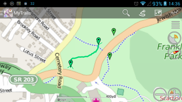
(The screenshot on the right was taken in the free version of MyTrails, the Android app that I use to track my walks through Franklin Park, as well as to note where I take some of my pictures. The placemark on the right of Jewish War Veterans Drive is where I take pictures of the white oak in Ellicottdale, and the one above it is the Wilderness Overlook where I took the first TestPics. .)

The path has a slight detour almost immediately. The path is supposed to go straight but a large tree fell across the path at some point in the past and the path simply jogged to the left up a small hill and around the tree. Some volunteers from Northeastern University tried to cut it with a hand saw last fall, but they were using a manual saw and the tree was simply too large to be beaten with their saw.
In the past the path was just a nice little trail to go down, but the same volunteers used some large branches and lined the edges of most of the path to show where the path goes once it gets past the fallen tree. I’m not entirely certain it was needed, as I would walk the path several times a week, but it looks pretty nice.

As you can see in the image above there’s a large boulder directly beside a tree. This boulder is a great place to lean against, especially on the back side of the boulder from this view, and there’s even a rise of ground that you can sit on if you want.

Even with the logs and branches stopping before the trail hits the turn to the left it’s pretty easy to tell where the trail goes. There are several paths off the trail, mostly to the left when you go in the direction I did, and some of them can get you to some nice places to sit for a spell, although some trails have enough branches across the path that you’ll want to watch where you’re going.

When you get down toward the end the main trail takes a sharp left toward Jewish War Veterans Drive, although if you want to go off to the right there’s another area to explore, and I plan on taking some pictures down that path this summer.

This end of the trail is Jewish War Veterans Drive between the Funeral Bridge and the Shattuck Hospital and Shelter. The entire path is pretty short, and according to MyTrails it’s a mere 300 yards long. I took 25 minutes to walk the path, but that’s because I kept stopping to take a new picture. There are a number of places to go off and explore, and while sometimes it can be a nice quiet trail there are times when you’ll run into several people walking the train. Some will have their dogs with them, and as a picture I posted to Instagram last weekend shows you can even see folks riding their bicycles on the path. They’ll watch for you, but you should watch for them as well.


Before I post this I’d like to give you an update on my Franklin Park book. Last fall I had said I would look at things in February and see if it would make sense to try another Kickstarter campaign to fund the creation of the book. As you can assume, I didn’t see that I had any better chances for a second Kickstarter campaign so the book still won’t be made. I will keep taking pictures in the park, and around Jamaica Plain, to post to my Twitter and Instagram feeds, but with the equipment I have the quality will be limited, as this group of pictures shows.
One thought on “TestPics: Forest Hills Corner”